
 (Cleveland)-A predicted strong storm system during the next 24-48 hours will bring an increased risk for showers and embedded thunderstorms in Georgia, that could produce damaging wind gusts as well as strong, gusty winds outside of any showers and thunderstorms beginning late tonight (Tuesday) and persisting into early Wednesday afternoon.
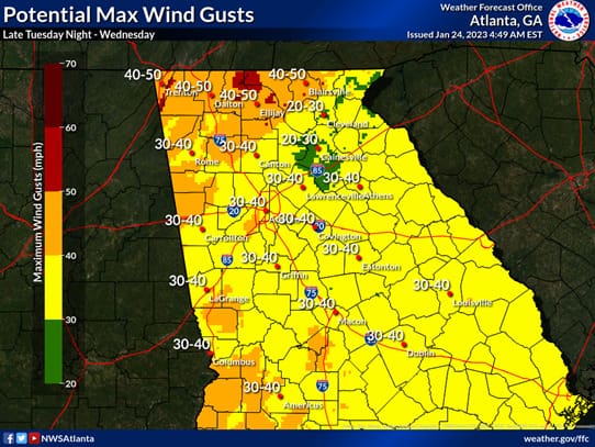
White County Deputy Emergency Management Agency Director Don Strength advised Tuesday morning that he expects any severe weather to stay south of an Atlanta to Augusta line. However, Strength believes strong non-thunderstorm winds and saturated soil could present an issue for White County with downed trees and power outages. The latest forecast calls for 20 – 30 mph wind gusts across White County reaching 40 mph on the ridge tops.
The National Weather Service released the following information about the approaching storm system:
Here are the highlights as of this morning (Tuesday, 1/24):
- A line of showers and a few embedded thunderstorms will push into Georgia ahead of a cold front after midnight during the early morning hours Wednesday and push eastward through early Wednesday afternoon.
- Primary storm threats (in order of concern):
- Strong to damaging wind gusts of 40-60+ mph (possible even in showers) – Primarily West Georgia
- Brief tornado (mainly in central Georgia)
- Locally heavy rainfall
- Additional weather concerns:
- Wind gusts of 35-40 mph (with localized higher gusts over 45-50 mph possible) are expected outside of any showers and storms beginning late Tuesday night through the day Wednesday, which will likely down some trees.
- A Wind Advisory will be in effect for the entire area from midnight tonight through midnight Thursday.
- Downed trees may be more likely due to the saturated ground from recent heavy rainfall.
- Timing of showers & storms:
- Entering west Georgia during the early predawn hours Wednesday morning, likely affecting ATL metro 6-9 AM.
- Moving eastward through the area from late morning through midday, likely exiting the southeast portion of the area during the early afternoon.


