
1/27/19
(Cleveland)- White County Public Safety Director David Murphy released this information following a weather briefing Sunday afternoon;
White County temperatures are forecast to change to the freezing mark on Tuesday by 11 AM, we could see snowfall before ground level temperatures hit the freezing point. Snowfall may be mixed with rain an hour or so before ground level temperatures get to freezing. All snow event after 11 AM Tuesday with a 70% chance of 1″ or greater snowfall with 3″ in higher elevations of our county.
Winds will pick up throughout the day Tuesday with speeds reaching 20-30 mph ushering in the arctic temperatures.
Tuesday night into Wednesday we have a significant threat of black ice. Any moisture left on roadways will freeze causing unsafe travel conditions. The arctic blast temperatures will be the coldest thus far this year with temps into dangerous wind chill conditions Wednesday morning. 9-14 degrees is forecast. Temperatures will not warm to above freezing until after lunch on Wednesday.
Below is the text of the National Weather Service notice issued Sunday afternoon.
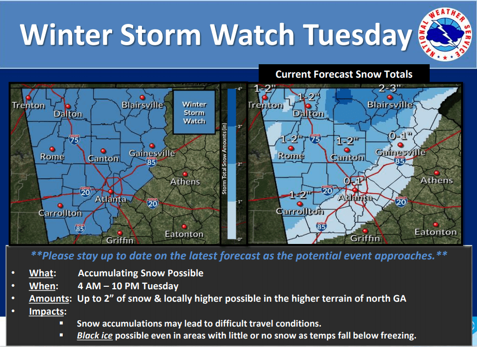
..WINTER STORM WATCH IN EFFECT FROM LATE MONDAY NIGHT THROUGH TUESDAY EVENING…
* WHAT…Snow possible. Total snow accumulations of up to 2
inches, with locally higher amounts possible in the higher
terrain of northern Georgia.
* WHERE…Mainly along and north of a line from Franklin to
Jonesboro to Gainesville.
* WHEN…From late Monday night through Tuesday evening.
* ADDITIONAL DETAILS…Travel could be very difficult. The
hazardous conditions could impact the morning or evening
commute.
PRECAUTIONARY/PREPAREDNESS ACTIONS…
A Winter Storm Watch means there is potential for significant
snow, sleet or ice accumulations that may impact travel. Continue
to monitor the latest forecasts.


